
Last updated:
Freeport/Surfside fishing report: conditions this week
Freeport/Surfside fishing report for Wed, Nov 4, 2026: Go for Thu, Nov 5. Water 77.4°F at Freeport Harbor (3:12 PM), wind E 9 kt, gusts 10 kt (NOAA/NDBC); biggest rising tide in daylight Thursday 6:59 AM–1:05 PM, 0.9 ft (NOAA predictions). This week: Go Thu · Go Fri · Maybe Sat · Skip Sun.
Freeport Harbor, Surfside Beach and Quintana (Gulf shore and jetties). Marine forecast, tides, water temperature and wind from NWS and NOAA, plus river flow and rainfall from USGS and nearby weather stations. Readings above: Snapshot from Nov 4, 3:23 PM CST refresh. Always check the live sources and any advisories before you go out.
Moving water, Thu, Nov 5: Biggest rising tide in daylight: 6:59 AM–1:05 PM, 0.9 ft (NOAA predictions, station 8772471; tide table. Wind can override them.)
Recent rain and runoff: No sign of heavy runoff: little or no recent rain and the Brazos River below normal.
- Brazos River near Rosharon: 531 cubic feet per second (24-hour average), about 26% of normal for Nov 4. Normal = USGS median daily flow for this date, 1968–2026 (55 years). Latest reading Nov 4, 2:45 PM CST, provisional. USGS 08116650
- Last 72 hours: 0.04 in of rain, measured at the Angleton/Lake Jackson (Texas Gulf Coast Regional) airport weather station (KLBX). IEM station data
- No strong north wind in the last 48 hours (NDBC FPST2) source
We don't measure water clarity. This line only says what high river flow, heavy rain or strong north wind can do, using the thresholds on How we rate. It doesn't change the call. Data as of Nov 4, 2:45 PM CST.
Live cams near this spot
Check the water yourself before you go. Free public cams near Freeport/Surfside:
- Surfside Jetty Park cam (opens in a new tab) (Brazoria County Parks, cam by Saltwater Recon). East jetty and surf at the Freeport channel mouth.
- Quintana Jetty cam (opens in a new tab) (Saltwater Recon, via Salty Forecast). Quintana beach toward the Freeport jetties.
We don't own or run these cams, and the call above is ours, not the cam's. Cams may be dark before sunrise. Links open the owner's page in a new tab (checked Oct 26, 2026).
No reports from Freeport/Surfside in the last 30 days. Send a report · Guides: get a free listing
NWS marine forecast
Coastal waters from Freeport to Matagorda Ship Channel TX out 20 NM; Coastal waters from High Island to Freeport TX out 20 NM (GMZ355)
- This afternoon: N 5–10 kt with higher gusts, seas 2–4 ft
- Tomorrow (Thu): E 5–10 kt, seas around 2 ft
Full NWS marine forecast
Issued 146 PM CST Wed Nov 4 2026 by NWS Houston/Galveston TX. Expires Nov 5, 2:30 AM CST.
.THIS AFTERNOON...North winds 5 to 10 knots with higher gusts.
Seas 2 to 4 feet. Wave Detail: North 3 feet at 4 seconds and
southeast 2 feet at 6 seconds.
.TONIGHT...East winds 5 to 10 knots. Seas around 2 feet. Wave
Detail: Northeast 1 foot at 4 seconds and southeast 1 foot at
6 seconds.
.THURSDAY...East winds 5 to 10 knots. Seas around 2 feet. Wave
Detail: South 1 foot at 4 seconds and east 1 foot at 4 seconds.
.THURSDAY NIGHT...East winds 5 to 10 knots, becoming northeast
after midnight. Seas around 2 feet. Wave Detail: Southeast 1 foot
at 5 seconds. A chance of showers.
.FRIDAY...Northeast winds 10 to 15 knots. Seas 2 to 3 feet. Wave
Detail: Northeast 2 feet at 3 seconds and southeast 1 foot at
6 seconds.
.FRIDAY NIGHT...Northeast winds 10 to 15 knots. Seas 2 to 3 feet.
Wave Detail: Northeast 2 feet at 3 seconds and south 1 foot at
5 seconds.
.SATURDAY...Northeast winds 15 to 20 knots, diminishing to around
15 knots in the afternoon. Seas 2 to 4 feet.
.SATURDAY NIGHT...Northeast winds 15 to 20 knots. Seas 3 to
5 feet.
.SUNDAY...Northeast winds 20 to 25 knots, diminishing to around
20 knots in the afternoon. Seas 3 to 5 feet.
.SUNDAY NIGHT...Northeast winds 10 to 15 knots. Seas 3 to 4 feet.
Source: tgftp.nws.noaa.gov/data/forecasts/marine/coastal/gm/gmz355.txt
Tide predictions
| Date and time (local) | Tide | Height (ft, MLLW) |
|---|---|---|
| High | 1.64 ft | |
| Low | 0.83 ft | |
| High | 1.75 ft | |
| Low | 1.18 ft | |
| High | 1.52 ft | |
| Low | 0.56 ft | |
| High | 1.93 ft | |
| Low | 1.36 ft |
NOAA CO-OPS predictions for station 8772471 (source). Predictions are astronomical. Wind and river flow can push actual water levels well above or below them, especially in Texas bays.
Sun & moon
Today, Nov 4, 2026, at Freeport/Surfside
- Sunrise / sunset
- 6:36a / 5:33p
- First / last light
- 6:11a / 5:58p
- Moon rise / set · over
- 2:12a / 2:50p · 8:35a
- Moon
- Waning crescent 20%
Many anglers fish around sunrise, sunset and moon overhead; weather, tides and fronts matter more.
Show next 7 days
Moon: waning crescent today; new moon Mon at 1:02a; waxing crescent Tue.
| Day | Sunrise | Sunset | Moonrise | Moonset | Moon overhead | Moon |
|---|---|---|---|---|---|---|
| Thu Nov 5 | 6:37a | 5:33p | 3:11a | 3:19p | 9:19a | Waning crescent, 13% |
| Fri Nov 6 | 6:37a | 5:32p | 4:09a | 3:49p | 10:02a | Waning crescent, 7% |
| Sat Nov 7 | 6:38a | 5:31p | 5:07a | 4:21p | 10:47a | Waning crescent, 3% |
| Sun Nov 8 | 6:39a | 5:31p | 6:05a | 4:56p | 11:33a | Waning crescent, 0% |
| Mon Nov 9 | 6:40a | 5:30p | 7:04a | 5:34p | 12:21p | New moon at 1:02a, 0% |
| Tue Nov 10 | 6:41a | 5:29p | 8:03a | 6:17p | 1:11p | Waxing crescent, 2% |
| Wed Nov 11 | 6:41a | 5:29p | 8:59a | 7:05p | 2:03p | Waxing crescent, 6% |
Sun is sunrise–sunset. Moon ↑ ↓ is moonrise then moonset, “Over” is when the moon is overhead, and “Lit” is the share of the moon illuminated. “—” means the event doesn't happen that day (the moon rises about 50 minutes later each day). First and last light are civil twilight.
Central Time for 28.936, -95.294 (NOAA CO-OPS station 8772471 Freeport Harbor), calculated at build time with U.S. Naval Observatory conventions.
Water temperature: NOAA CO-OPS 8772471 Freeport Harbor, Nov 4, 2026, 3:12 PM local, source. Wind: NDBC FPST2, source. Waves: NDBC buoy 42019 (offshore, not inside the bay), source.
Bank, wade and jetty access
Public spots from official or park pages (checked Oct 25, 2026). Tap a spot for details, fees and links.
Shore & public access (4) · tap to showtap to hide
Surfside Jetty County Park (East Jetty) Jetty and channel · 8 a.m. to dusk
A 15-acre Brazoria County day-use park at the foot of the East Jetty, with paved parking, restrooms and access to the beach, the Freeport ship channel and the jetty. The paved jetty is about 6/10 mile long. The county says day and night fishing along the jetty and ship channel is popular. The county lists day-use hours of 8 a.m. to dusk; its page lists no entry fee.
Quintana Beach County Park and the Quintana jetty Jetty, surf and pier · 8 a.m. to dusk
A county beach park whose half-mile pedestrian beach ends at the Quintana jetty, the west jetty of the Freeport ship channel. The county allows surf fishing anywhere along the beach and requires a fishing license to fish anywhere in the park. It also lists a lighted fishing pier at the west end, but the Brazosport visitors bureau says the pier is closed after Hurricane Nicholas damage, so check with the park before you plan on it. Day-use hours are 8 a.m. to dusk. From Memorial Day weekend through Labor Day weekend there is a $5 per-vehicle parking fee at the gate. No glass containers ($500 fine), and pets must be leashed.
Brazoria County Parks · Visit Brazosport (pier closure) · Google Maps
Surfside Beach Surf and beach · $15 daily beach permit
The Village of Surfside Beach allows driving on the beach east of Highway 332 (street-legal vehicles only, one-way eastbound, 15 mph). The village asks visitors to do the stingray shuffle when entering the water and not to leave bait, fish or crab remains on the beach. Glass containers are banned. Vehicles driving or parking on the beach need a beach permit: $15 daily (good until midnight) or $30 annual (good for the rest of the calendar year), sold at the beach booth entrances or City Hall.
Bryan Beach, Freeport Surf and beach · free primitive camping
The City of Freeport says Bryan Beach has nearly three miles of regularly maintained natural beach, used for camping, cookouts and shore fishing. Brazoria County lists Bryan Beach among nearby beaches with free primitive tent camping for up to two weeks at a time. We found no official hours, fees or vehicle rules for Bryan Beach, so check with the City of Freeport before you go.
Check before you go. Hours, fees and access change, and storms close piers and jetties. We have no live status for any of these spots, so call or check the linked page first. Jetty rocks are slippery, and wading means shuffling your feet for stingrays (wade fishing gear and safety).
Local guides & marinas on Freeport/Surfside
Guides: send a report, get a free listing. A few lines on how the fish were biting, in your own words, goes on this page with a link to your business. We don't write the report for you, and we don't invent catches.
Marinas and bait shops can get listed free too. Listings don't change the lake or bay data.
Gear for this bay
Fishing Freeport/Surfside for redfish, speckled trout or flounder? Our spec comparisons cover the inshore spinning setups and wade-fishing safety gear Texas bay anglers use most:
- Best inshore spinning reels & rods for Texas bays: sealed and saltwater-rated reels, 7'–7'6" rods, braid and leader basics.
- Texas wade fishing gear: stingray boots and guards, wading belts, stringers and fish bags, inflatable PFDs, plus the stingray shuffle.
Inshore species basics
Inshore species basics (4) · tap to showtap to hide
General notes for Texas bays, not a report for Freeport/Surfside. Size limits, bag limits and seasons change, so check the current TPWD Outdoor Annual before keeping fish. Quick summary of licenses, red drum, seatrout and flounder limits: our License & regulations guide.
Full guides: Redfish in Texas · Speckled trout in Texas · Southern flounder in Texas · Black drum in Texas
Redfish (red drum)
Found across Texas bays, from shallow grass flats and shorelines to marsh drains, oyster reefs, jetties and passes. Commonly caught on live or cut bait (shrimp, mullet, menhaden), gold spoons, soft plastics and topwaters. Texas has a slot limit with a special tag rule for oversized fish. Check the current rules.
Spotted seatrout (speckled trout)
Often around grass beds, reefs, guts and drop-offs, and under birds working shrimp. Popular methods include live shrimp under a popping cork, soft plastics and topwaters early and late. Trout are sensitive to sudden cold snaps, and TPWD has adjusted trout limits in recent years, so verify the current bag and size limits.
Southern flounder
Ambush feeders on muddy or sandy bottoms near structure, drains, channels and pass edges. Fished slowly near the bottom with live bait or soft plastics, or gigged at night. Flounder migrate toward the Gulf passes in fall, and the Texas flounder fishery is closed Nov. 1–Dec. 14 (TPWD, checked Oct. 20, 2026).
Black drum
Found in every Texas bay, from clear sand flats to muddy sloughs, piers and channels. Usually caught on the bottom with peeled shrimp, cut bait or crab; big "bull" drum school up in late winter. Texas has a 14–30 inch slot with one fish over 52 inches allowed per day.
Freeport/Surfside depth chart
NOAA nautical chart (ENC data, paper-chart symbols) with depths, channels, markers and reefs. Tap to open an interactive version you can pan and zoom.
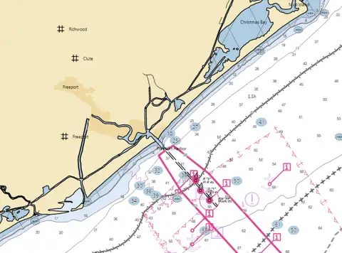
Not for navigation. This is a web display of NOAA chart data for planning and reference only. Use official, up-to-date NOAA charts, local notices and your own eyes on the water. Shallow Texas bays shift after storms.
Chart: NOAA Office of Coast Survey, NOAA Chart Display Service (public domain, updated weekly). Preview rendered Oct 25, 2026. Official sources for this area: NOAA ENC Viewer · NOAA Chart Locator. Also see C-MAP's free web map.
Freeport/Surfside FAQ
Is Freeport/Surfside fishing good this week?
Our call for Thu, Nov 5 is Go: moderate tide in daylight (0.9 ft), light wind (up to 10 kt) and water 77°F at Freeport Harbor. Next days: Go Thu · Go Fri · Maybe Sat · Skip Sun. It's a rule-based estimate from the NWS marine forecast, NOAA tides and wind, not a catch report.
What is the water temperature in Freeport/Surfside today?
77.4°F at NOAA station 8772471 Freeport Harbor, 3:12 PM local time.
Is there a Freeport/Surfside fishing report from TPWD?
TPWD's weekly Gulf Coast fishing reports have been on hold since the week of Feb. 25, 2026 (TPWD, checked Oct 25, 2026). This page updates conditions three times a day from NWS and NOAA, and anglers can send a report.
Where can I fish from a pier or the bank at Freeport/Surfside?
Public spots on this page include Surfside Jetty County Park (East Jetty) (jetty and channel, 8 a.m. to dusk), Quintana Beach County Park and the Quintana jetty (jetty, surf and pier, 8 a.m. to dusk) and Surfside Beach (surf and beach, $15 daily beach permit). Hours and fees change, so check the linked official pages in the access section before you go.
Can I keep flounder in Freeport/Surfside now?
No. Texas flounder fishing is closed Nov. 1 through Dec. 14: the bag limit is 0, so no flounder may be kept by any method, including gigging. It reopens Dec. 15 (TPWD).
Fishing with kids? TPWD stocks catfish and trout at 4 Neighborhood Fishin' ponds in the Houston area: Burke-Crenshaw Lake · Community Park Lake (Missouri City) · Herman Little Pond · Mary Jo Peckham Park.